 FAO Map Catalog
FAO - FIRI
Type of resources
Available actions
Topics
Keywords
Contact for the resource
Provided by
Representation types
Update frequencies
status
Resolution
-

Road network in Africa classified according to their accompanying road type classification system. The cost grid represents the time cost and it is assumed that the time required to travel from one cell to another in absence of main roads is 5 times longer than the time needed on the main road. Road network was derived from ArcWorld (ESRI, 1992).
-

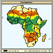
Mean annual wind velocity (meters/sec) across Africa. Mean annual wind velocity was obtained from UNEP/DEIA/GRID-Geneva.
-
Spatial distribution of water temperature regimes most favourable for warm water fish farming given one and two crops per year. Using the Nile tilapia as a model, fish farming was assessed for three water temperature regimes corresponding to two crops/year with good growth (temperature)
-
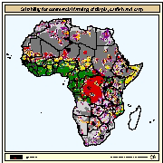
Map derived from the combined suitability of areas apt for commercial fish farming development and operation with areas with potential yield (crops/y) of Nile tilapia, African catfish and Common carp for small-scale farming. Areas with suitability for commercial fish farming were derived from the combined suitability of five land-quality factors important for fish farming development and operation; net annual water requirement for shallow ponds, soil and terrain suitability for the construction of fish ponds, potential livestock wastes and agriculture by-products as feed and fertilizer inputs, potential for farm-gate sales and potential market demand. Predictions of growth were based on water temperature, in turn predicted from air temperature and wind velocity data. Gridded values of mean monthly daily minimum and maximum temperatures were obtained from the Centre for Resource and Environmental Studies (CRES) at the Australian National University. Mean annual wind velocity was obtained from UNEP/DEIA/GRID-Geneva.
-
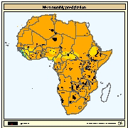
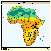
Mean monthly gridded values for precipitation in Africa. Data obtained from the Centre for Resource and Environmental Studies (CRES) at the Australian National University.
-
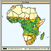
Spatial distribution of water availability for fish ponds. Map derived from the combined suitability of annual rainfall with density of perennial streams and rivers. Annual rainfall interpreted as rainfall runoff to fill fishponds. Mean annual precipitation data for Africa were obtained from UNEP/GRID in Nairobi and was developed for the Global Assessment of Soil Degradation (GLASOD) using data from 1951-1980. A digital map of perennial streams and rivers was generated by ESRI (1984).
-
Monthly potential evapotranspiration values according to Penman-Monteith method for Africa. Data obtained from the International Institute for Applied Systems Analysis (IIASA).
-
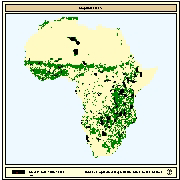
Areas in which supplementary food such as agricultural by-products could contribute to the establishment of pond culture systems such as integrated agriculture-aquaculture farming. Data on crops were derived from USGS's Global Land Cover Characteristics database.
-
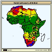
Spatial distribution of potential yield (crops/y) of Nile tilapia for commercial farming. Predictions of growth were based on water temperature, in turn predicted from air temperature and wind velocity data. Gridded values of mean monthly daily minimum and maximum air temperatures were obtained from the Centre for Resource and Environmental Studies (CRES) at the Australian National University. Mean annual wind velocity was obtained from UNEP/DEIA/GRID-Geneva.
-
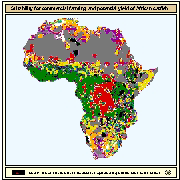
Map derived from the combined suitability of areas apt for commercial fish farming development and operation with areas with potential yield (crops/y) of African catfish for commercial farming. Areas with suitability for commercial fish farming were derived from the combined suitability of five land-quality factors important for fish farming development and operation; net annual water requirement for shallow ponds, soil and terrain suitability for the construction of fish ponds, potential livestock wastes and agriculture by-products as feed and fertilizer inputs, potential for farm-gate sales and potential market demand. Predictions of growth were based on water temperature, in turn predicted from air temperature and wind velocity data. Gridded values of mean monthly daily minimum and maximum temperatures were obtained from the Centre for Resource and Environmental Studies (CRES) at the Australian National University. Mean annual wind velocity was obtained from UNEP/DEIA/GRID-Geneva.